
Cedar Rapids Neighbor Source Map
The most defensible answer about a Cedar Rapids block is a map relationship. City and county GIS layers can show parcel bounds, situs addresses, legal descriptions, tax districts, deed-owner fields, and public parcels. A situs address is the location assigned to the parcel. It may differ from the owner's mailing address. Association and election tools describe civic geography, not household membership.
| Source | What It Shows About a Block | Access |
|---|---|---|
| Cedar Rapids APV | City parcel shapes, address, class, acreage, and deed or contract fields | Free official map |
| Linn County land-record map | County parcels, legal descriptions, owner fields, tax districts, and recorder links | Free official map |
| Linn County election lookup | Precinct, districts, ballot, and polling place for an address | Free address check |
| Neighborhood dashboard | Mapped association, contact, meeting, and boundary details | Free city dashboard |
| Historical archive | Dated directory, census, Sanborn, and newspaper block context | Web archive and local repositories |
Deed-owner and contract-owner fields should keep those exact labels. A parcel may belong to an estate, trust, company, government body, or person who receives mail elsewhere. The map cannot identify every occupant. For neighbors, it establishes recorded parcel relationships as of a capture date, not a current household list.
Choose Cedar Rapids Parcel Records
A parcel inside the city begins with the Cedar Rapids APV. Its residential data includes GISNUM, house number, street name, deed holder, contract field, class, acres, assessment components, DBA, and geometry. Land outside the city assessment system belongs in the Linn County land-record map, which adds GPN, situs city and ZIP, tax districts, assessor, recorder date, book, page, and instrument links.
Check the municipality flag before comparing lots. Two parcels that appear side by side can fall under different assessors. Keep the city GISNUM or county GPN with each row, along with the layer and date viewed. If the geometry conflicts with the legal description, ask GIS staff or the Linn County Recorder instead of choosing the shape that looks right.
Map Cedar Rapids Neighbor Parcels
Start from one exact address or parcel identifier. Confirm that the point lies inside the expected polygon, then walk outward one parcel at a time. Mark whether each nearby lot touches the target, sits across a mapped street or alley, or merely appears in the same view. Rivers, rail lines, rights-of-way, and condominium common areas can break apparent adjacency.
- Find the target in Cedar Rapids APV or Linn County GIS and verify its parcel shape.
- Click polygons on every side. Separate touching lots from those across a street, alley, waterway, or rail line.
- Save parcel ID, situs address, short legal description, class, dated deed or contract field, and recorder link.
- Open AVA only when an instrument number, date, book, or page is needed to confirm the recorded link.
Use the legal description as the stable bridge when a street number is unclear. For a full named-road chain beyond the immediate block, the Cedar Rapids street directory follows address-keyed records farther.
Record Cedar Rapids Block Evidence
A useful adjacent-parcel table keeps the map relation and source strength visible. Label directions as touching north, east, south, or west, across a street or alley, or same-block nearby. Then add the city GISNUM or county GPN, current situs address with quadrant, legal description, published class, municipality, dated owner-field label, recorder reference, and source confidence.
- Parcel
- A mapped tract with its own city or county identifier.
- Legal description
- The lot, block, subdivision, or other land wording used in recorded documents.
- Situs address
- The physical parcel address, distinct from a tax-mailing address.
- Source confidence
- Whether the result comes from GIS alone, a deed index, a reviewed image, or remains unresolved.
A recorder instrument number often distinguishes a current deed more reliably than a common owner name. That local shortcut is valuable when several Cedar Rapids neighbors share a surname or when a trust name appears in the parcel field.
Cedar Rapids Neighborhood Associations
The Cedar Rapids Neighborhood Associations dashboard maps organized groups and provides contacts and meeting details. The city guide says Cedar Rapids has more than twelve associations. A dashboard result of “None” means the selected location lacks a mapped association in that layer. It does not mean the area has no civic ties.
| Association | Meeting place | Schedule shown |
|---|---|---|
| Cleveland Area | Central Church of Christ | Third Monday, 7:00 p.m. |
| Ellis Harbor | NW Recreation Center | Fourth Monday, 6:30 p.m. |
| Kenwood Park | Kenwood Park United Methodist Church | Second Monday, 7:00 p.m. |
| Mound View | Mission of Hope | Third Thursday, 7:00 p.m. |
| Noelridge Park | Noelridge Park Baptist Church | Meeting detail through dashboard |
The Community Development and Planning office is the official fallback for an unmapped area or an outdated association record. Association contacts build community links, but they are not member rosters and should not be used to infer every household on a Cedar Rapids block.
Cedar Rapids Civic Neighbors
The Linn County address lookup begins with a house number and matching address. It can return the next active election, sample ballot, voting details, precinct, city or township, council district, school district, county supervisor district, Iowa House and Senate districts, judicial district, and federal representative. It does not name individual voters.
The official Linn County address lookup capture below shows the election tool used for Cedar Rapids neighbors.
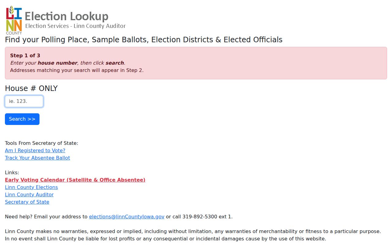
That output adds civic context to adjacent parcels without exposing a block roster. District, ZIP, neighborhood, and parcel lines can cross in different places, so keep each geography as its own layer.
Trace Past Cedar Rapids Neighbors
Historical neighbors require dated sources. Begin at a known intersection in the Cedar Rapids Community History Archive. The directory street guide supplies a sequence of house numbers, Sanborn fire-insurance maps show building footprints, census pages connect households to a moment in time, and newspapers can explain a move, sale, or institutional use.
Cedar Rapids address identity depends on the NW, NE, SW, or SE quadrant set by 1st Avenue and the Cedar River. A one-character OCR mistake can move a result to another part of town. Inspect the page image and adjacent pages. When a structure was replaced or renumbered, use town-lot deeds and plats to hold the land trail steady. A historic directory entry must always retain its printed year and cannot prove a current neighbor.
Cedar Rapids Neighbor Tool Choices
Official sources and commercial neighbor tools answer different questions. Government layers publish records within a named jurisdiction and provide a custodian for corrections. Commercial tools may combine parcel associations and paid feeds from different dates. Their update cycles, fees, and correction routes vary, and a merged result can hide which field came from which source.
| Choice | Strength | Limit |
|---|---|---|
| Official GIS and assessor | Dated parcel geometry and labeled owner fields | Ownership is not occupancy |
| Recorder AVA | Instrument, party, date, book, page, and legal description | Index is not always the document image |
| Election and association maps | Precinct, district, meeting, and civic boundary context | No household roster |
| Commercial category | May combine several feeds | Variable dates, provenance, fees, and corrections |
For Cedar Rapids neighbors, official maps and the Recorder offer the clearest dated evidence. Keep each field linked to its agency and never merge uncertain results into a personal profile.
Cedar Rapids River Block Clues
The Cedar River is both an address baseline and a physical break in Cedar Rapids neighborhood research. Along with 1st Avenue, it helps define the city's NW, NE, SW, and SE address quadrants. Near the river, a parcel that seems close on a broad map may be separated by water, flood works, a bridge approach, a rail corridor, or public land. Mark those features before calling two parcels adjacent.
The 2008 flood also matters when tracing historic blocks and civic institutions. Downtown library records and local-history resources became spread among the Cedar Rapids Public Library, its Community History Archive, the Genealogical Society of Linn County, the National Czech & Slovak Museum & Library, and the State Historical Society. A missing volume or image should lead to the next repository, not to a claim that no record exists.
May's Island provides another geographic clue. Cedar Rapids became the Linn County seat after the 1919 vote, moving the administrative focus from Marion and placing later courthouse research at the river. For present-day neighbors, these facts help explain why parcel, court, archive, and association sources have different boundaries and custodians. Keep the layer name, record date, and office with every finding.
Protect Cedar Rapids Neighbors
Public parcel ownership does not disclose every person who lives nearby. Utility accounts, delivery records, full birth dates, identification numbers, and protected addresses do not belong in a neighbor table. Safe at Home and Protect Our Protectors can substitute or suppress addresses for eligible participants. An absent public address may be an intentional safeguard, not a bad search.
Iowa voter lists also have purpose, field, cost, and timing limits. The public verification tool checks information supplied by the searcher, while the county address tool returns district data. Neither authorizes a list of all Cedar Rapids neighbors on a block. If a record is wrong, send the correction to its assessor, recorder, clerk, election office, or archive rather than spreading the error.
Lawful use. Research Cedar Rapids neighbors for civic, historical, and personal purposes. Never use records to watch, harass, intimidate, or harm someone.